Region Remains Under Flood Watch
Thursday June 20th, 2019, 9:21pm
Hello time traveller!!
This article is 1863 days old.
The information listed below is likely outdated and has been preserved for archival purposes.

The Essex Region Conservation Authority has extended its long-term flood watch, first issued on May 30th, until June 28th.
According to officials, the current Lake Erie and Lake St. Clair Lake levels are exceeding the record highs set 1986 for the month of May. It is expected that lake levels will continue to meet or exceed these record highs in June and July.
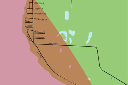
“Current lake levels are approximately at the same starting elevation, before wind and waves, as the original shoreline hazard mapping completed in 1976,” said James Bryant, Water Resources Engineer. “As a result of high water levels, the region has experienced 9 flood events this spring with the most impacted area being east Leamington and more specifically, the shoreline between Point Pelee National Park and the Town of Wheatley.” Additionally, because of high water levels, flood events are occurring and have the potential to occur from much lower wind speeds from any direction. This, combined with shoreline infrastructure that has been weakened from multiple years of wave action and high waters, results in greater risks to shoreline communities.
ERCA continues to monitor conditions and issue flood messages, and advise on repairs and improvements to areas of concern and damaged infrastructure. However, based on observations, current threats and future impacts, there is a need to further investigate and complete Watershed-Based Flood Risk Assessments in collaboration with municipal partners.
“The original flood line mapping for the Essex Region shoreline was completed in 1976, which excludes the high lake level periods through the 1980s, 1990s, and our present levels,” adds Bryant. “This information greatly influences the starting lake elevation prior to applying wind and wave action. Updated mapping is required to best protect the residents of the region from the ongoing impacts of flooding and erosion.