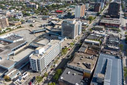


Lauzon Parkway EA Underway
Tuesday April 12th, 2011, 11:15am
Hello time traveller!!
This article is 4761 days old.
The information listed below is likely outdated and has been preserved for archival purposes.

The Ontario Ministry of Transportation, the City of Windsor and the County of Essex have retained McCormick Rankin Corporation to begin the Class Environmental Assessment Study to address the future requirements for Lauzon Parkway.
The study will consist of four parts:
This project is a Class Environmental Assessment (EA) Study of the following:
Part A – Lauzon Parkway
The existing section of Lauzon Parkway between E.C. Row Expressway and County Road 42 consists of a 4-lane cross-section at its interchange with E.C. Row Expressway. South of the interchange, the roadway tapers to a 2-lane cross-section. The roadway also includes a grade separated crossing at the CPR rail line, as well as, a bridge crossing at the Little River Drain.
This study will examine the future needs of this existing section of Lauzon Parkway and its potential extension to Highway 401 and Highway 3.
Part B – County Road 42
County Road 42 between Walker Road and County Road 25 is approximately 15.5 km. This 2-lane roadway includes multiple residential and commercial driveways with direct access.
This study will examine the future needs of the existing County Road 42 to 2031.
Part C – Future East/West Arterial
The Future East/West Arterial was identified as part of the City of Windsor’s East Pelton Secondary Plan, which was completed for a portion of the Sandwich South lands. The East Pelton Secondary Plan identified a corridor for the new arterial between Walker Road and County Road 17.
This study will examine the future alignment and current and future needs for the proposed East/West Arterial, including connections to the existing transportation network.
Part D – Sandwich South Secondary Plan Study
The lands requiring a Secondary Plan are generally bounded by the CPR mainline (north of the Windsor Airport) to the north; Lauzon Road and the 8th Concession to the west and the City of Windsor boundary to the east and south. The objective of the Secondary Plan Study is to develop a general framework for future development of the remainder of the Sandwich South lands.
There will be a public open house in the summer.